GEOL105 Chapter Notes - Chapter 11: Natural Hazard, Coastal Engineering, Predictable Process

31 May 2018
School
Department
Course
Professor

CH 11: Coastal Hazards
11.1 Introduction to Coastal Hazards
● Coastal areas are dynamic environments that vary in their topography, climate, and
organisms
● Continental and oceanic processes converge to produce landscapes that are capable of
rapid change
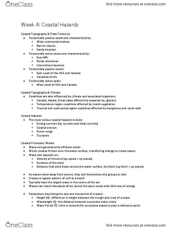
● Coastal topography is greatly influenced by plate tectonics
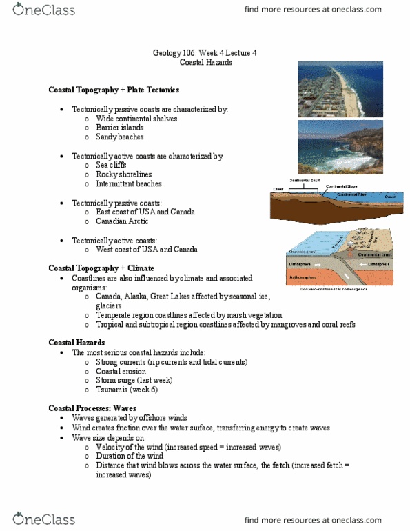
● US and Canada east coasts are described as tectonically passive bc they are not close
to a convergent plate boundary
○ Typically have wide continental shelves with barrier islands and sandy beaches
● US and Canada west coasts are tectonically active bc they are close to transform
boundaries between the North American and Pacific plates
○ Mountain building produces coasts with sea cliffs and rocky shorelines
● The impact of hazardous coastal processes is considerable bc many populated areas
are located near the coast
● In the US, it is expected that most of the population will eventually be concentrated along
the nation’s 150,000 km of shoreline
● Population density for coastal counties is six times greater than that of inland counties
● Most serious coastal hazards include
○ Strong coastal currents
○ Coastal erosion
○ Storm surge from tropical and extratropical cyclones
○ Tsunamis
11.2 Coastal Processes
Waves
● Waves that batter the coast are generated by offshore winds
● The size of waves depends on a combination of the following:
○ The velocity or speed of the wind (the stronger the wind speed, the larger the
waves)
○ The duration of the wind (winds that last longer have more time to impart energy
to the water, thereby producing larger waves)
○ The distance that the wind blows across the water surface (this distance is
referred to as the fetch; a longer fetch allows larger waves to form)
● Rogue wave: a huge wave that is created by a number of factors, seems larger than the
rest
○ Most appear to be formed by constructive interference
○ In this process, multipole, similarly sized waves intersect to create a much larger
wave
○ Undersea irregularities and currents also influence the formation
○ These waves can be extremely dangerous
○ May appear out of nowhere
● Three parameters describe the size and movement of a wave
find more resources at oneclass.com
find more resources at oneclass.com

○ Wave height (H): the difference in height between the trough and crest of a wave
○ Wavelength (L): the distance between successive wave crests
○ Wave period (T): the time in seconds for successive waves to pass a reference
point
● Swell: wave sets generated by storms far out at sea
● Wave energy is approximately proportional to the square of the wave height
● Variations along a coastline
○ The wave height along a coast may increase or decrease as waves approach the
shore caused by irregularities in the offshore topography of the seafloor and by
changes in the shape of the coastline
○ Wave front: a long, continuous crest of a single oscillation, such as one on the
surface of a lake or ocean
○ Irregular coastlines have small rocky peninsulas known as headlands
■ The shoreline between headlands may be relatively straight or somewhat
curved
○ Refraction: bending of a waveform. With respect to coastal processes, the
bending of surface waves as they enter shallow water. This takes place where
part of the wave “feels the bottom” and slows down while the remainder of the
wave continues to move forward at a faster velocity
● Effects of wave refraction
○ To visualize the effects of wave refraction, draw a series of imaginary lines called
wave normals, perpendicular to the wave fronts, and add arrows pointing toward
the shoreline
○ The resulting diagram shows that wave refraction causes a convergence of the
wave normals at the headland and a divergence of the wave normals along the
shoreline away form the headland
○ Where wave normals converge, both wave height and the energy expended by
the waves increase
● Breaking waves
○ Breaking waves may peak up quickly and plunge or surge, or they may gently
spill, depending on local conditions
○ Waves that plunge are called plunging breakers
■ They typically form on steep beaches and tend to be more erosive
○ Waves that spill are spilling breakers
■ Commonly develop on wide, nearly flat beaches and are more likely to
deposit sand
○ The type of breaker that occurs changes seasonally and with changes in
underwater slope and topography
○ Large plunging breakers that form as the result of storms cause much of the
coastal erosion
Beach Form and Processes
● Beach: a landform consisting of loose material, such as sand or gravel, which has
accumulated by wave action at the shore line
● The beach onshore
find more resources at oneclass.com
find more resources at oneclass.com

○ Sea cliff: the landward extent of the beach that is generally a cliff (called bluff
along a lakeshore)
○ A line of sand dunes
○ Or a line of permanent vegetation
○ The onshore portion of most beaches can be divided into two areas:
■ One that slopes landward (called a berm)
■ Another that slopes toward the water (called the beach face)
○ Swash zone: the part of the beach face that experiences the uprush and
backwash of waves
■ This zone shifts in size and location with changes in water level resulting
from storms or, on sea coasts, from tides
● The beach offshore
○ Surf zone: the portion of the nearshore environment where turbulent water
moves toward the shore after the incoming waves break
○ Breaker zone: the area where incoming waves become unstable, peak, and
break
○ Longshore bar: a sandbar; forms beneath each line of breaks in the breaker zone
● Sand transport
○ Littoral transport: movement of sediment in the nearshore environment as a
result of return flow form waves that have washed up on the shore; sediment is
moved by both the longshore current and by beach drift
■ In beach drift, the up and back movement of beach material in the wash
zone causes sediment to move long a beach in a zigzag path
■ Longshore drift refers to the transport of sediment by ocean currents that
flow essentially parallel to the shoreline
○ The terms updrift and downdrift are often used to indicate the direction in which
sediment is moving or accumulating along the shore
11.3 Sea-Level Change
● Relative sea level: the position of the sea at the shore
○ Influenced by both the movement of the land and the movement of the water
○ These movements can be local, regional, or global in extent
● Eustatic sea level: global sea level
○ Controlled by processes that affect the overall volume of water in the ocean and
the shape of the ocean basins
● Eustatic sea level
○ Climate, primarily the avg air temp, exerts the greatest control on the amt of
water in the ocean today
○ As the avg temp of the ocean incs, the volume of water expands; as it cools, the
volume of water contracts
○ Thermal expansion or contraction, global warming or cooling of the
atmosphere is responsible for this phenomenon
● Relative sea level
find more resources at oneclass.com
find more resources at oneclass.com
Document Summary
Coastal areas are dynamic environments that vary in their topography, climate, and organisms. Continental and oceanic processes converge to produce landscapes that are capable of rapid change. Coastal topography is greatly influenced by plate tectonics. Us and canada east coasts are described as tectonically passive bc they are not close to a convergent plate boundary. Typically have wide continental shelves with barrier islands and sandy beaches. Us and canada west coasts are tectonically active bc they are close to transform boundaries between the north american and pacific plates. Mountain building produces coasts with sea cliffs and rocky shorelines. The impact of hazardous coastal processes is considerable bc many populated areas are located near the coast. In the us, it is expected that most of the population will eventually be concentrated along the nation"s 150,000 km of shoreline. Population density for coastal counties is six times greater than that of inland counties. Storm surge from tropical and extratropical cyclones.