GEOG 1200 Lecture Notes - Lecture 3: Mercator Projection, Stock Exchange, Ontario Food Terminal

29 Oct 2018
School
Department
Course
Professor

Geo 1200
September 14, 2018
https://courselink.uoguelph.ca/d2l/le/content/524161/viewContent/1943357/View Wednesdays
https://courselink.uoguelph.ca/d2l/le/content/524161/fullscreen/1946166/View
From Wednesdays slides
Slide 9:
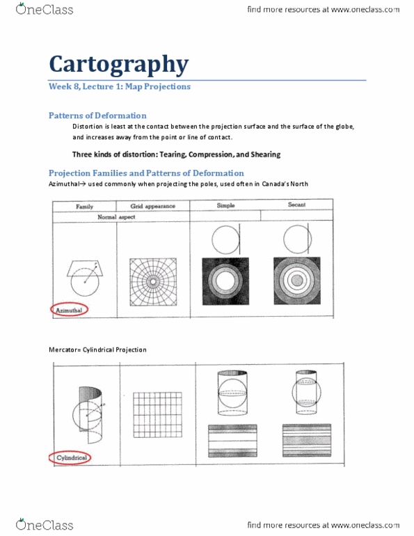
● Map Projections
- Systematic rending of the earths surface onto a flat surface
Slide 10:
● Distortion of distance, direction, shape, area
● Image on the slideshow of an example of map projections
Slide 11:
● Equidistant
- Preserve distance
● Conformal
- Preserve compass direction
E.g. Mercator projection – map used for many years
o Many things wrong with this map, lots of distortion with size and poles
o Map is political b/c it is made by the northern countries
● Azimuthal
- Preserve compass direction
Slide 12:
● Equal Area/ Equivalent
- Proportions
e.g. Peters
o Shows all the countries in equal proportions
o Sending piece from this map
o Preserving area of the land
● Other Map Types
- Robison
Slide 13:
● Shows the Peters vs. Robinson
Slide 14:
● Cartogram
- Cartogram demonstrating spatial inequality of all people living on US $10 or
less a day
o Map shows a representation of unevenness due to $10 or less a day
Slide 15:
● GIS
- Geographic Information System: a collection of computer hardware and
software and analysis of layers of spatial data
o Diagram shows the different layers used in GIS
Slide 16:
● Remote Sensing
- A method of collecting data by instruments that are physically distant from
the area of study
e.g. satellites
New slides from today
Slide 2:
● Spatial Analysis
- Location
- Distance
- Spatial interactions
- Scale
Slide 3:
● Location
- Absolute location
o The measure (e.g., lat/ long coordinates) or representation of a single
position (e.g., dot map)
o Diagrams show the running lines of latitude and longitude
Slide 4:
● Coordinates of our class
Slide 5:
● Distance
- Absolute distance
o The physical separation between two points on the earths surface
measured by an accepted standard unit, such as kms
Document Summary
Systematic rending of the earths surface onto a flat surface. Image on the slideshow of an example of map projections. Mercator projection map used for many years: many things wrong with this map, lots of distortion with size and poles, map is political b/c it is made by the northern countries. Proportions e. g. peters: shows all the countries in equal proportions, sending piece from this map, preserving area of the land. Cartogram demonstrating spatial inequality of all people living on us or less a day: map shows a representation of unevenness due to or less a day. Geographic information system: a collection of computer hardware and software and analysis of layers of spatial data: diagram shows the different layers used in gis. A method of collecting data by instruments that are physically distant from the area of study e. g. satellites.