GEOG 216 Lecture Notes - Lecture 7: Hydrograph, Capillary Action, Soil Horizon

18 May 2018
School
Department
Course
Professor

Goal:&identify&the&dynamic&relationships&between&runoff&and&river&processes
Hydrologic&cycles&
Global&hydrology&(liquid&water&makes&the&Earth&unique&in&our&solar&system&–Mars&maybe,&Titan?)
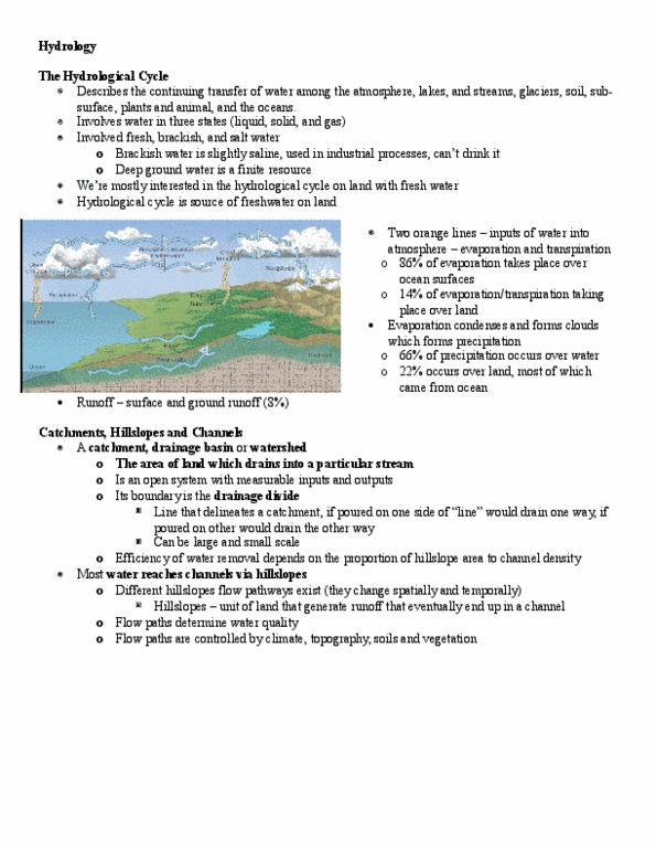
Water&covers&70%&of&the&Earth's&surface,&but&it&is&difficult&to&understand&the&total&amount&of&water&
when&we&see&only&a&small&portion&of&it.&This&diagram&displays&the&volumes&of&water&contained&on&land,&
in&oceans,&and&in&the&atmosphere&(see&diagram).&Arrows&indicate&the&annual&exchange&of&water&
between&these&stores.
§
The&oceans&contain&97.5%&of&the&Earth's&water,&land&2.4%,&and&atmosphere&0.001%
§
○
•
Hydrology&is&readily&subdivided&into&several&sub-disciplines&(surface&or&subsurface,&hillslope,&fluvial).&Hill&slope&
hydrology&is&concerned&with&the&movement&of&water&when&it&arrives&on&the&ground&surface&and&the&paths&it&takes&
to&get&into&the&rivers&and&lakes.&
•
HYDROGRAPH)WILL)BE)ON)THE)FINAL
A&hydrograph&is&a&plot&(graph)&of&river&discharge&over&time,&a&storm&or&unit&hydrograph&plots&the&response&in&river&
discharge&to&a&precipitation&event
•
One&of&the&best&indicators&of&a®ion's&hydrologic&character
•
The&hydrograph&(graph&of&a&river&discharge&over&time)&tells&us&a&lot&about&the&character&of&a&drainage&basin&and&in&
particular&the&role&of&runoff
•
Hillslope)hydrology
The&rate&at&which&a&river&responds&to&a&rainfall&event&is&closely&related&to&the&way&water&makes&its&way&into&the&
river.&The&area&that&contributes&water&to&stream&flow&is&called& the&drainage(basin,(water&moves&through&the&
drainage&basin&2&ways:&as&surface)flow (runoff&and&rivers)&and&as&groundwater.
•
The&groundwater&input&into&rivers&is&called base)flow.
•
What&happens&when&it&rains?
Precipitation&-runoff&-evapotranspiration&-evaporation
•
Remember:&precipitation&includes&rain,&snow,&hail,&dew,&fog,&frost,&etc.
•
Precipitation:&through-fall,&interception&storage,&leaf&drip,&stem&flow
•
Infiltration&–movement&of&water&through&the&soil&profile&(no&flow;&capillary&flow;&saturated&flow)
•
Hygroscopic&water&–water&retained&by&surface&tension&around&individual&soil&grains
•
What&controls&rates&of&infiltration:
Porosity
○
Grain&size
○
Permeability
○
Moisture&content
○
Vegetation&cover
○
Slope&angle
○
Rainfall&intensity&and&duration
○
•
Runoff&occurs&when&the&rate&of&rainfall&exceeds&the&infiltration&rate&(Hortonian&overland&flow)&or&when&the&ground&
is&saturated
•
Runoff,&interflow,&through-flow•
Return&flow&=&subsurface&storm&flow•
Runoff)and)erosion
At&the&onset&of&a&runoff,&a&sheet&of&water&begins&to&flow&over&the&ground&surface&–sheet&flow,&this&flow&exerts&
small&stresses&on&the&ground&surface&which&when&aided&by&raindrop&impacts&can&cause&sheet&and&rain&splash&
erosion
•
As&flow&progresses&downslope,&it&becomes&funnelled&into&small&channels&called&rills.&As&rills&join&together,&they&
form&larger&channels&called&master&rills&and&the&gullies.&This&involves&rill&and&gully&erosion.
•
Universal&soil&loss&equation:&A&=&R*K*L*S*C*P&in&tons&per&acre&per&year
A&=&erosion&soil&loss&in&tons&per&acre&per&year
○
R&=&rainfall&factor
○
K&=&soil&erodibility&factor
○
L&=&slope&length&factor
○
S&=&slope&gradient&factor&(%&steepness)
○
…
○
•
Direct)runoff)regime
2&models:
Partial&area:&where&runoff&area&increases&during&a&single&storm&event
○
Variable&source:&where&runoff&area&varies&through&the&season
○
•
Direct&runoff&varies&with:
Topography
○
Soil&characteristics
○
Antecedent&moisture
○
Rainfall
○
•
Same&pattern,&just&different&time&scales•
<-- These&3&factors&control&infiltration&capacity&(max)
7.2:%Hillslope%hydrology%and%drainage%basins
Thursday,& February& 22,&2018
10:16&AM

Goal:&identify&the&dynamic&relationships&between&runoff&and&river&processes
Hydrologic&cycles&
Global&hydrology&(liquid&water&makes&the&Earth&unique&in&our&solar&system&–Mars&maybe,&Titan?)
Water&covers&70%&of&the&Earth's&surface,&but&it&is&difficult&to&understand&the&total&amount&of&water&
when&we&see&only&a&small&portion&of&it.&This&diagram&displays&the&volumes&of&water&contained&on&land,&
in&oceans,&and&in&the&atmosphere&(see&diagram).&Arrows&indicate&the&annual&exchange&of&water&
between&these&stores.
§
The&oceans&contain&97.5%&of&the&Earth's&water,&land&2.4%,&and&atmosphere&0.001%
§
○
•
Hydrology&is&readily&subdivided&into&several&sub-disciplines&(surface&or&subsurface,&hillslope,&fluvial).&Hill&slope&
hydrology&is&concerned&with&the&movement&of&water&when&it&arrives&on&the&ground&surface&and&the&paths&it&takes&
to&get&into&the&rivers&and&lakes.&
•
HYDROGRAPH)WILL)BE)ON)THE)FINAL
A&hydrograph&is&a&plot&(graph)&of&river&discharge&over&time,&a&storm&or&unit&hydrograph&plots&the&response&in&river&
discharge&to&a&precipitation&event
•
One&of&the&best&indicators&of&a®ion's&hydrologic&character•
The&hydrograph&(graph&of&a&river&discharge&over&time)&tells&us&a&lot&about&the&character&of&a&drainage&basin&and&in&
particular&the&role&of&runoff
•
Hillslope)hydrology
The&rate&at&which&a&river&responds&to&a&rainfall&event&is&closely&related&to&the&way&water&makes&its&way&into&the&
river.&The&area&that&contributes&water&to&stream&flow&is&called& the&drainage(basin,(water&moves&through&the&
drainage&basin&2&ways:&as&surface)flow (runoff&and&rivers)&and&as&groundwater.
•
The&groundwater&input&into&rivers&is&called base)flow.•
What&happens&when&it&rains?
Precipitation&-runoff&-evapotranspiration&-evaporation•
Remember:&precipitation&includes&rain,&snow,&hail,&dew,&fog,&frost,&etc.•
Precipitation:&through-fall,&interception&storage,&leaf&drip,&stem&flow•
Infiltration&–movement&of&water&through&the&soil&profile&(no&flow;&capillary&flow;&saturated&flow)
•
Hygroscopic&water&–water&retained&by&surface&tension&around&individual&soil&grains
•
What&controls&rates&of&infiltration:
Porosity
○
Grain&size
○
Permeability
○
Moisture&content
○
Vegetation&cover
○
Slope&angle
○
Rainfall&intensity&and&duration
○
•
Runoff&occurs&when&the&rate&of&rainfall&exceeds&the&infiltration&rate&(Hortonian&overland&flow)&or&when&the&ground&
is&saturated
•
Runoff,&interflow,&through-flow•
Return&flow&=&subsurface&storm&flow•
Runoff)and)erosion
At&the&onset&of&a&runoff,&a&sheet&of&water&begins&to&flow&over&the&ground&surface&–sheet&flow,&this&flow&exerts&
small&stresses&on&the&ground&surface&which&when&aided&by&raindrop&impacts&can&cause&sheet&and&rain&splash&
erosion
•
As&flow&progresses&downslope,&it&becomes&funnelled&into&small&channels&called&rills.&As&rills&join&together,&they&
form&larger&channels&called&master&rills&and&the&gullies.&This&involves&rill&and&gully&erosion.
•
Universal&soil&loss&equation:&A&=&R*K*L*S*C*P&in&tons&per&acre&per&year
A&=&erosion&soil&loss&in&tons&per&acre&per&year
○
R&=&rainfall&factor
○
K&=&soil&erodibility&factor
○
L&=&slope&length&factor
○
S&=&slope&gradient&factor&(%&steepness)
○
…
○
•
Direct)runoff)regime
2&models:
Partial&area:&where&runoff&area&increases&during&a&single&storm&event
○
Variable&source:&where&runoff&area&varies&through&the&season
○
•
Direct&runoff&varies&with:
Topography
○
Soil&characteristics
○
Antecedent&moisture
○
Rainfall
○
•
Same&pattern,&just&different&time&scales•
<-- These&3&factors&control&infiltration&capacity&(max)
7.2:%Hillslope%hydrology%and%drainage%basins
Thursday,& February& 22,&2018 10:16&AM
Document Summary
Goal: identify the dynamic relationships between runoff and river processes. Global hydrology (liquid water makes the earth unique in our solar system mars m. Water covers 70% of the earth"s surface, but it is difficult to understand the t when we see only a small portion of it. This diagram displays the volumes of wa in oceans, and in the atmosphere (see diagram). Arrows indicate the annual e between these stores. The oceans contain 97. 5% of the earth"s water, land 2. 4%, and atmosphere 0. Hydrology is readily subdivided into several sub-disciplines (surface or subsurface, hillslope hydrology is concerned with the movement of water when it arrives on the ground surfac to get into the rivers and lakes. A hydrograph is a plot (graph) of river discharge over time, a storm or unit hydrograph plo discharge to a precipitation event. One of the best indicators of a region"s hydrologic character.