PLS 147 Lecture Notes - Lecture 1: California Oak Woodland, Understory, Wildfire


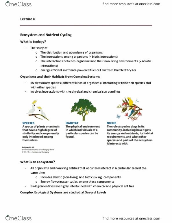
plant community
ecological community
ecosystem
● set of interacting plants that co-occur in a particular place and
time
○ also their characteristics like relative abundance and
spatial distributions
w/ animals and microbes
w/ abiotic and landscape-scale aspects like nutrient cycling,
topography, soils
can we classify and
delineate plant
communities as
separate entities
are there really sharp
boundaries?
How do we describe
a community?
vegetation map
● maps imply boundaries and ecotones
● how they are often distributed is more variable
● lines are arbitrary
sharp boundaries can occur when
● spatial
○ abrupt change in soils or hydrology
■ eg serpentine soils, vernal pools, riparian
○ a community dominante determines the
presence/absence of many species
■ eg timberline (edges of the trees b/c pine
needles change the soil, etc), grasslands,
sierra conifers
● temporal
○ succession after a fire
plant communities are both real & imagined. even though boundaries
are fuzzy and variable, it is still helpful for us to label them.
Floristics (species name)
● what species are there and their relative abundance
Physiognomy (what it looks like)
● cover, height, life forms
● eg forest/grassland/shrubland
community names are a mixture of both
● eg coast redwood forest, oak woodland, perennial bunchgrass
prairie
Forest
nearly complete woody canopy cover (60-100%)
● implies a certain height, cant see sky

Woodland
Savanna
Grassland
Shrub
moderate canopy cover (25-60%)
low canopy cover (10-25%)
● mainly open, few trees
little/no woody cover (0-10%)
● prairie
variable cover
● chaparral: complete woody cover but low height
different systems use different cut-offs for a continuous variation
canopy layers
emergent trees
● rare, very tall like forest trees
canopy
● main layer
sub-canopy
● and shrub layer
woody understory (shrub layer)
herbaceous understory (ground vegetation)
plant life forms
herbaceous: not woody
● annual or perennial
● grass or forb ("herb" eg wildflowers)
semi-woody (suffrescent)
woody
● tree (single stem)
● shrub (multiple stemmed, short)
Trees
● coniferous/needle-leaved
○ all evergreen (and gymnosperms)
● broad-leaved
○ evergreen
○ deciduous
■ winter or summer (dry)
hierarchy organization: series & association (europe: class & order
too)
Document Summary
Set of interacting plants that co-occur in a particular place and time. Also their characteristics like relative abundance and spatial distributions w/ animals and microbes w/ abiotic and landscape-scale aspects like nutrient cycling, topography, soils vegetation map. How they are often distributed is more variable. Lines are arbitrary sharp boundaries can occur when. A community dominante determines the presence/absence of many species. Eg timberline (edges of the trees b/c pine needles change the soil, etc), grasslands, sierra conifers. Succession after a fire plant communities are both real & imagined. even though boundaries are fuzzy and variable, it is still helpful for us to label them. What species are there and their relative abundance. Eg forest/grassland/shrubland community names are a mixture of both prairie. Eg coast redwood forest, oak woodland, perennial bunchgrass. Implies a certain height, cant see sky. Rare, very tall like forest trees canopy. And shrub layer woody understory (shrub layer) herbaceous understory (ground vegetation) herbaceous: not woody.